Maps and Directions
Thanks to
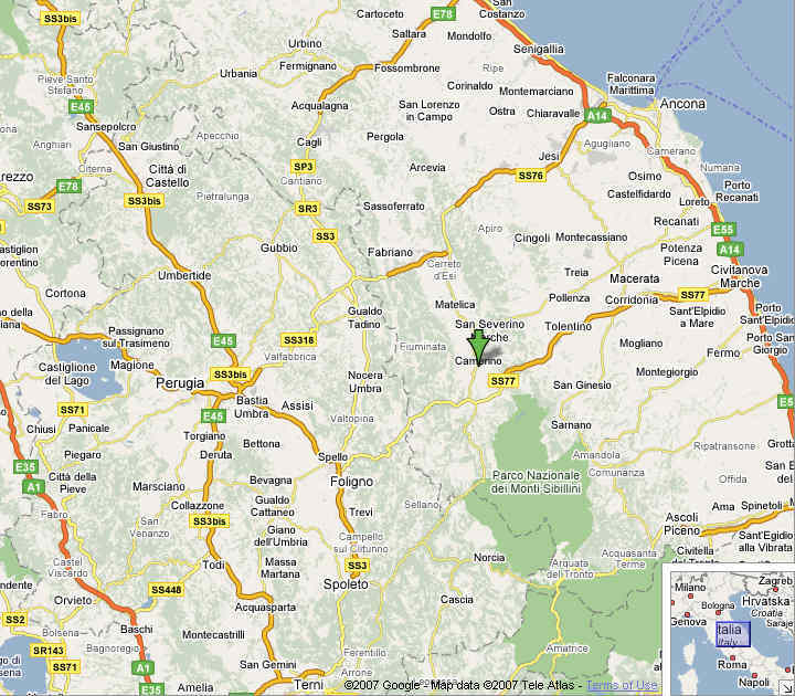
Google Maps for supplying this
more detailed map of the region, centred on Camerino.

Microsoft can provide a
Satellite view of the
properties, this shows how the accommodation is rural, yet still close
enough for a quick visit to Camerino.
For those who want to know
exactly
where the properties are, the coordinates are: 43° 09.796' N
13° 04.709' E
Information on how to obtain paper maps and guidebooks of the
region can be found on the
attractions
page.
Airports
Ryanair
and
EasyJet
fly
into many regional airports. These include (with travel time by car to
Camerino):
Ancona
(1h
15 mins)
Perugia (1h 20 mins)
Rimini (1h 45 mins)
Pescara (2 hours)
Bologna Forli (2h 30 mins)
Rome Ciampino (3h 30 mins)
Many
international carriers, including
BA, fly into Rome
Fiumicino (3h 30 mins). It is worth checking prices into Fiumicino, as
in some cases they can be comparable to the "budget" airlines. BA also
flies from London Gatwick into Bologna (3 hours).
Directions
From Falconara Airport
(Ancona)
After
you have left the airport behind, take the first right turn onto the
dual-carriage road (S76), following the signposts to Rome. After some
40 kilometres,
the dual carriageway ends and you pass through a series of tunnels.
After the
last of these (you know it is the last because there are no more and
the
mountains have been left behind) you continue for about a kilometre
where there
is a road to the right signposted for Camerino. Take this road and
follow it
through Cerreto d’Esi and Matelica. You then come to Castelraimondo but
you do
not enter the town. Keep on, following the

signs
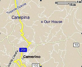
to Camerino. After some 4
kilometres, you arrive at a very small village called Canepina. There
is very
little there but, on the right, you will pass a bar and, immediately
afterwards, a post office on the left. Then there is a cemetery on the
right.
Just ahead of this, there is a road to the right (leading to the
Camerino
sports centre). When you see this, begin signalling to turn left
because,
almost immediately after the road to the right, there is one to the
left
(without a signpost).
This left turn is
the road you want.
After about a kilometre and several bends, just
after passing a restaurant on the left, a farm on the right and a
couple of
houses, on a bend there is a left turn off the road into the
strada bianca (‘white road’) leading to
the house – when it’s hot, the road is dusty and, after rain, a bit
muddy but
all year round it’s somewhat bumpy! The
road goes first goes down a steep slope at the bottom of which is a
bend that
leads to a bridge crossing a small river. Carry along the road that
goes up a
hill, past a house at the right and just before you arrive at another
half-restored house, you turn right into a long private road that leads
only to the house. You drive through the open gates and you have
arrived.
From Rome
Head north along the A1 motorway (towards Florence). You leave this
road
at Orte. After paying your toll,
turn right on the road heading for Terni.
Continue
to Spoleto and then to Foligno.
Here
you leave this road, following signs to Camerino and Macerata. You
climb up
through the mountains, passing through Colfiorito and Seravalle di
Chienti.
Shortly afterwards, you leave turn off the road to the left signposted
for
Camerino. You continue to wind your way up the mountains but,
eventually you
begin to descend and Camerino lies ahead. Just after driving through
the small village of Morro, you pass the Camerino
hospital on the left and the road joins another. Turn left on the new
road
(towards Camerino and follow the bends up the hill. Do not
follow the signs to the right for Camerino. Continue along
the
road (250) and, after less than a kilometre, you pass through a small
tunnel.
There is then a road to the right. Do not
take this but continue but stay
on the road that sweeps round a bend. Just after this, there is a road
off to
the right. This is the one you
want!
Go up the hill to the top where there is a T-junction. Turn left there,
passing
the supermarket, Il Paniere. Stay on this road. After some 400 metres,
you will
pass on the right, a long tree-shaded drive to Villa Ridente. Shortly
afterwards, there is a blind corner round a house next to the road.
After that
you can see your destination, a white house, across the valley to the
right. After
passing two more
houses on the right,
on a bend, is the strada bianca
(‘white road’) leading to that house. It first goes down a steep slope
at the
bottom of which is a bend that leads to a bridge crossing a small
river. Carry
along the road that goes up a hill, past a house at the right and just
before
you arrive at another half-restored house, you turn right into a long
private
road that leads only to the house. You drive through the open gates and
you have arrived.
Use of GPS systems
In general it is better to try to use the directions above to reach the
property; however we have successfully tested entering the exact
co-ordinates (43° 09.796' N
13° 04.709' E) into version 6 of TomTom. The system then directed us correctly to our front door!

 signs
to Camerino. After some 4
kilometres, you arrive at a very small village called Canepina. There
is very
little there but, on the right, you will pass a bar and, immediately
afterwards, a post office on the left. Then there is a cemetery on the
right.
Just ahead of this, there is a road to the right (leading to the
Camerino
sports centre). When you see this, begin signalling to turn left
because,
almost immediately after the road to the right, there is one to the
left
(without a signpost). This left turn is
the road you want.